The Surrey Gardens TRA covers Lorrimore Square, Lorrimore Road, Carter Street and Forsyth Gardens - SE17, London (see here for a map), and is responsible for the maintainence of the park in Lorrimore Square.
The area has a rich history. A 1681 map of Walworth made for Dean and Chapter of Canterbury Cathedral shows a common called "Lattam-more" (or Lower Moor), later becoming "Lorrimore" and lending its name to various streets in the area.
In 1831, Lorrimore Common (as the area was then known) was sold to Edward Cross who used it to host the Royal Surrey Gardens (hence the name of the TRA), which featured lions and tigers amongst other animals. As the gardens declined in popularity the area was once again sold, and in 1872 the common was largely developed for housing.
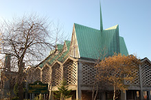
 St Paul's Church (one of two churches within the area covered by the TRA - the other being St Wilfrid's Roman Catholic Church, Lorrimore Road, built in 1914) is located in the centre of the square. In 1940, during the Second World War, incendiary bombs hit the original church (which had been completed and consecrated in 1856) and destroyed it, leaving only the steeple. The current church, which was built in 1959–60, is Grade II listed and used some of the original church materials in its construction.
The same incendiary bombs destroyed a number of houses in Lorrimore Square itself, leading to the development of newer flats on the north and south west sides. Carter Street was also subject to bombing.
Those houses that escaped destruction date largely to the 1850s - 1870s. The age and importance of these buildings has been recognised by their inclusion in the Sutherland Square Conservation Area, to ensure their protection for years to come.
In 1831, Lorrimore Common (as the area was then known) was sold to Edward Cross who used it to host the Royal Surrey Gardens (hence the name of the TRA), which featured lions and tigers amongst other animals. As the gardens declined in popularity the area was once again sold, and in 1872 the common was largely developed for housing.
 St Paul's Church (one of two churches within the area covered by the TRA - the other being St Wilfrid's Roman Catholic Church, Lorrimore Road, built in 1914) is located in the centre of the square. In 1940, during the Second World War, incendiary bombs hit the original church (which had been completed and consecrated in 1856) and destroyed it, leaving only the steeple. The current church, which was built in 1959–60, is Grade II listed and used some of the original church materials in its construction.
The same incendiary bombs destroyed a number of houses in Lorrimore Square itself, leading to the development of newer flats on the north and south west sides. Carter Street was also subject to bombing.
Those houses that escaped destruction date largely to the 1850s - 1870s. The age and importance of these buildings has been recognised by their inclusion in the Sutherland Square Conservation Area, to ensure their protection for years to come.


No comments:
Post a Comment